

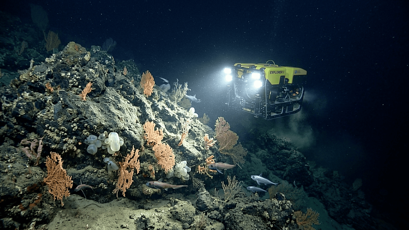
A South Atlantic field expedition used sonar and remotely operated vehicles to examine deep-sea seamount habitats and document their communities. The observations add baseline evidence that can guide future biodiversity research and help assess potential risks from human activity on the seafloor.
TLDR: A South Atlantic expedition used sonar and remotely operated vehicles to investigate seamount habitats far below the sunlit ocean. Its imagery documented deep-sea corals, sponges and mobile animals, adding biological detail to seafloor maps. Researchers say repeat surveys and carefully targeted sampling are needed to understand how these communities vary and change.
A research expedition to the South Atlantic has brought new detail to a largely unseen part of the ocean: the deep seafloor around seamounts, where underwater slopes and peaks can support rich communities of life. Scientists aboard the Schmidt Ocean Institute research vessel Falkor (too) used remotely operated vehicles to explore these isolated habitats, recording animals and seafloor features that are difficult to observe from the surface.
Seamounts rise from the ocean floor but may remain far below the reach of sunlight. Their steep sides can redirect currents, carrying food particles past rocky surfaces where corals, sponges and other organisms settle. The expedition’s camera-equipped vehicle allowed researchers to examine these environments directly, instead of relying only on sonar maps or samples collected by nets.
The footage showed a varied deep-sea community. Corals and sponges provide structure on otherwise exposed rock, creating places for other animals to live. Researchers also documented mobile species, including fish and invertebrates, moving through the camera’s field of view. Such observations help scientists distinguish between a bare geological feature and a habitat with ecological importance.
The work matters because the deep ocean is vast, and much of its seafloor has not been mapped at a resolution useful for understanding individual habitats. A broad sonar survey can reveal a mountain or canyon, but close-up video can show whether it supports fragile organisms, how species are distributed, and what physical conditions surround them. Combining the two approaches makes it easier to identify areas that merit further study.
Seamount communities can be vulnerable to disturbance. Deep-water corals often grow slowly, and damage to their structures may take a long time to recover. Fishing gear that contacts the bottom can break corals or disturb sponges, while changing ocean conditions can affect the food supply and chemistry on which deep-sea organisms depend. The expedition’s observations offer a baseline against which future surveys can be compared.
A remotely operated vehicle also gives researchers a way to gather samples selectively. Video helps identify organisms and locations before a collection arm is used, reducing the need for indiscriminate sampling. Even then, identifying deep-sea species can be challenging: many look similar, and some specimens require genetic analysis or comparison with museum collections before their identity is clear.
The expedition’s records add to a growing international effort to document deep-ocean biodiversity. Scientists use such data to ask how species move between seamounts, whether isolated peaks host distinct communities, and how currents shape the distribution of life. Repeated visits are especially valuable because a single expedition captures conditions at one point in time. Long-term changes can only be understood through consistent observations and measurements.
The findings also have practical value for ocean management. Better maps and biological records can help decision-makers assess the ecological consequences of activities such as bottom fishing or seabed mining. The presence of corals or other sensitive organisms does not by itself determine policy, but it provides evidence needed to weigh risks and identify places where more information is necessary.
Researchers still face major gaps: many deep-sea areas have never been visited, and even mapped regions may lack biological surveys. Future expeditions can revisit the sites, collect carefully chosen specimens, measure currents and water chemistry, and compare habitats across a wider stretch of ocean. That work will help establish how common these communities are and whether they are changing. For now, the expedition’s clearest contribution is a closer look at an ocean landscape that remains largely out of sight, and a stronger foundation for studying and protecting it.

Ethan Blake serves as a Senior Correspondent for Just Right News, where he specializes in Longform Narrative and Public Understanding. In an era of rapid-fire headlines and fleeting soundbites, Ethan’s work stands as a testament to the power of deep-dive reporting and the importance of contextualizing the complex issues facing the nation today. His approach is rooted in the belief that the most profound truths are often found in the lived experiences of individuals rather than the abstract theories of distant policymakers.
Growing up in Providence, Rhode Island, Ethan developed an early appreciation for the historical and cultural threads that weave the American fabric together. Providence, a city defined by its industrial heritage and its blend of traditional neighborhoods, provided him with a front-row seat to the challenges and triumphs of the American working class. This upbringing instilled in him a respect for the “common sense” values of hard work, community loyalty, and the preservation of local institutions. He learned early on that behind every economic statistic or legislative debate, there are real families and neighborhoods navigating the consequences of change.
This foundational perspective is the driving force behind his signature feature series, “Lives Behind the Systems.” Through this series, Ethan explores the intersection of individual agency and institutional structure. Whether he is documenting the impact of federal land-use policies on rural families or examining how shifting educational standards affect local school boards, Ethan’s work prioritizes the human element. He seeks to uncover how large-scale systems—be they governmental, economic, or social—affect the daily lives of citizens, often advocating for a return to local control and personal responsibility.
Now based in Portland, Maine, Ethan draws significant inspiration from the rugged independence and self-reliance that define the region. The coastal landscape and the resilient spirit of Maine’s communities serve as a constant reminder of the importance of individual liberty and the strength found in decentralized power. Living and working outside the traditional media hubs allows Ethan to maintain a grounded perspective, ensuring his reporting remains untethered from the echo chambers of the major metropolitan centers. This geographic distance provides him with the clarity needed to translate complex national narratives into stories that resonate with the heart of the country.
At Just Right News, Ethan’s beat is more than just a professional assignment; it is a mission to foster a more informed and engaged citizenry. He believes that a free society depends on the public’s ability to understand the mechanisms of power and the value of traditional American principles. His longform narratives do not merely report the news; they provide a roadmap for understanding the cultural and political shifts of the modern era through a lens of skepticism toward centralized authority and a deep respect for the individual.
Through his meticulous research and narrative craftsmanship, Ethan Blake continues to bridge the gap between policy and the public. His work remains a vital resource for those who seek a deeper understanding of the systems that shape our world and the enduring spirit of the people who live within them.