

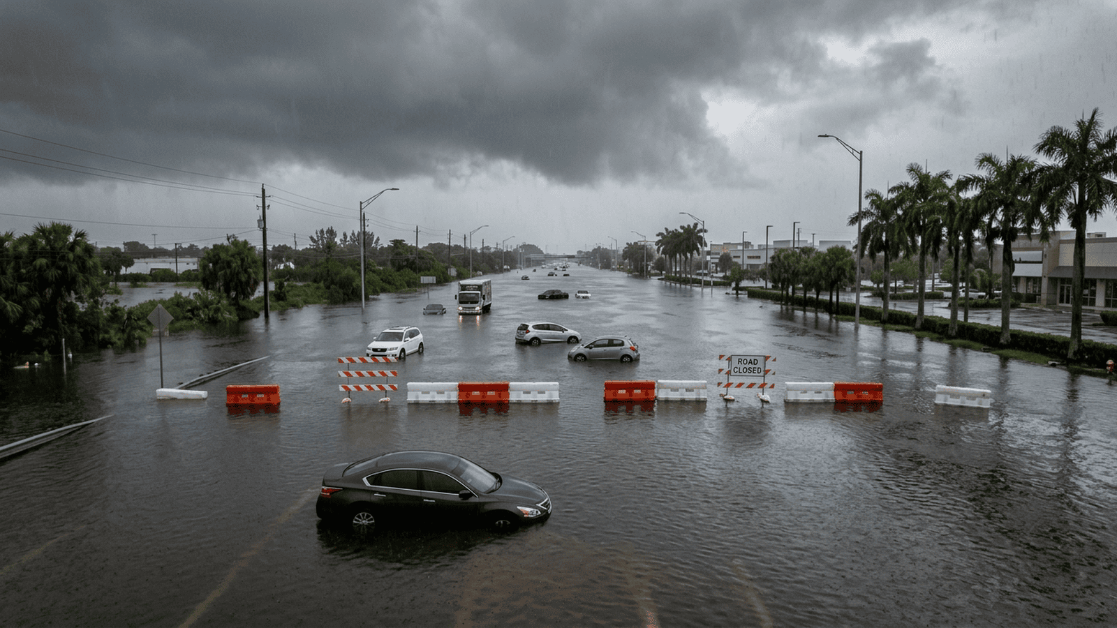
Heavy rain flooded parts of South Florida, submerged cars, closed sections of major roads and led Hollywood to declare an emergency. Weather Service figures showed up to a foot of rain in parts of Broward County in 24 hours, with as much as 12 more inches possible along Florida’s Atlantic Coast through Friday. Meteorologists linked the pattern in part to El Niño’s disruption of the state’s usual dry season. Storm impacts also reached California, where flights and ferries were disrupted, highways were blocked and an evacuation warning covered three burn scar areas through Friday morning. Officials urged people to avoid unnecessary travel and issued time-limited warnings as forecasts called for continued rain, wind and mountain snow.
TLDR: Officials have closed flooded roads, declared an emergency in Hollywood and warned of more rain on Florida’s Atlantic Coast through Friday. California is also dealing with travel disruptions and a burn-scar evacuation warning, with local advisories and forecasts setting the next steps.
South Florida is facing a severe rainfall event, with flooded roads, submerged cars and an emergency declaration in place Wednesday. The immediate response has been practical: local officials closed roads, urged motorists to stay off them and issued warnings about further hazards. Those steps limit travel and choice, but they give residents clear instructions while dangerous conditions persist.
There is no new government policy described in the report. The stated explanation for the weather is that El Niño is disrupting Florida’s usual dry season, which runs from October through May. National Weather Service meteorologist Alejandra Garcia said the warming cycle is helping bring low-pressure systems toward the Southeast and contributing to heavy precipitation.
Preliminary figures showed that parts of Broward County received as much as a foot of rain in the 24 hours ending Wednesday morning. The threat along Florida’s Atlantic Coast was expected to continue through Friday, with another 12 inches possible. The Florida Division of Emergency Management warned that potentially catastrophic rainfall could bring flash floods and life-threatening rip currents, along with minor beach erosion from high surf.
Hollywood declared a state of emergency Wednesday. Mayor Josh Levy urged motorists to stay off the roads and avoid unnecessary travel, a direct restriction on routine movement that reflects the risks officials described. Portions of the Florida Turnpike and Interstate 95 in Hollywood closed because of high water and stalled vehicles. The city reported more than 300 calls for service overnight.
The consequences were visible across the city. Heavy rain caused the roof of Temple Sinai to collapse, though no injuries were reported. Some residents told Levy that fast-moving cars sent wakes into their homes, adding a human cause to damage already worsened by high water. Levy called the rainfall historically significant for Hollywood.
Other measurements show how unusual the downpour was. Fort Lauderdale recorded 5.72 inches of rain in a storm ending early Wednesday, breaking the daily record of 1.8 inches set in 1959. Plantation recorded the highest total cited in the report. In northern Florida, officials issued a warning for minor flooding along the St. Johns River.
The storm’s reach extends beyond Florida. On the West Coast, heavy rain and high winds grounded planes at San Francisco International Airport, disrupted ferry service and flooded roads in Napa County and other wine country areas. Floodwater covered parts of San Francisco’s Embarcadero, where waves crossed recently installed barriers near the Ferry Building. Officials canceled several ferries, while flooding or debris blocked highways in Napa, Marin, San Mateo and Santa Clara counties.
California also faced risks beyond flooded streets. The Los Angeles County Fire Department issued an evacuation warning for the Palisades, Hurst and Sunset burn scar areas because of possible debris flows. The warning was set to remain in effect from Wednesday evening through Friday morning. Rain that began north of San Francisco was expected to spread south to the Central Coast, while forecasts called for wind gusts up to 50 mph in the East Bay and 70 mph at Altamont Pass. Up to four feet of snow was forecast in the highest Sierra Nevada areas through Friday.
The practical impact is immediate for people who travel or live in affected areas. Florida drivers face closed sections of the Turnpike and I-95, a request to avoid unnecessary trips and the possibility of more rain through Friday. California travelers face canceled ferries, grounded flights, blocked highways and an evacuation warning with a stated end time of Friday morning. The report lists no fees, required forms or broader compliance program, and it describes no new rule imposing those burdens. The limits on movement come from road closures and official safety guidance, not from a permanent change in individual rights.
The event also shows where infrastructure is being tested. Flooding reached roads in Florida and California, and waves overtopped barriers installed near San Francisco’s Ferry Building. The storm disrupted transportation and damaged a synagogue roof. The report does not identify the cost of repairs, the source of funding or any planned infrastructure work, so those details remain unknown rather than assumed.
The next steps are tied to the weather outlook and local warnings. Florida’s coastal rainfall threat was expected to last through Friday, and a low-pressure system near the northern Bahamas could develop into a subtropical or tropical storm over parts of the Southeast and Mid-Atlantic into early next week. California’s evacuation warning also runs through Friday morning. Those timelines are necessary steps for people and officials to track changing conditions and follow local safety instructions; the report provides no further oversight schedule or official assurance that all risks are under control.

Mark Davis serves as the Senior Correspondent for Energy, Climate, and Resource Economics at Just Right News. In an era where the conversation around the environment is often dominated by alarmism and top-down mandates, Mark provides a vital, market-oriented perspective on the complex forces shaping our world. As the lead voice behind the acclaimed feature series “Power and the Planet,” he explores the intersection of environmental policy, global energy markets, and the fundamental economic principles that sustain modern civilization.
Mark’s pragmatic approach to resource management was forged in the high desert of his hometown, Albuquerque, New Mexico. Growing up in a region defined by both its breathtaking natural beauty and its rugged, resource-dependent landscape, he developed an early appreciation for the delicate balance between conservation and utilization. New Mexico’s unique position as a hub for both traditional energy production and cutting-edge scientific research provided Mark with a front-row seat to the evolution of the American energy sector. This upbringing instilled in him a deep-seated belief that true environmental stewardship is inseparable from economic prosperity and technological innovation.
Now based in Boulder, Colorado, Mark operates from the heart of the nation’s climate research community. While Boulder is often seen as a bastion of environmental idealism, Mark utilizes his post to provide a necessary counterweight, grounded in the realities of resource economics. He understands that energy policy does not exist in a vacuum; it has tangible consequences for the American taxpayer, the stability of the national power grid, and the strength of the domestic manufacturing sector. By reporting from the front lines of the climate debate, he is able to challenge prevailing narratives with hard data and a commitment to the principles of the free market.
Throughout his tenure at Just Right News, Mark has distinguished himself by focusing on the “Resource Economics” aspect of his beat. He frequently highlights the hidden costs of rapid energy transitions and advocates for an “all-of-the-above” energy strategy that prioritizes American energy independence. His work often shines a light on the geopolitical implications of resource scarcity, arguing that a secure nation must first be an energy-secure nation. Whether he is analyzing the impact of federal land-use regulations or investigating the supply chains required for new technologies, Mark remains focused on how policy decisions affect the lives and livelihoods of everyday citizens.
In “Power and the Planet,” Mark continues to bridge the gap between complex scientific concepts and the economic realities facing the country. He rejects the false choice between a healthy environment and a thriving economy, instead seeking out solutions that leverage American ingenuity and private-sector competition. For Mark, reporting on the climate is not about following the latest trends, but about ensuring that the conversation remains tethered to the foundational values of liberty, property rights, and fiscal responsibility. His contributions ensure that Just Right News readers receive a comprehensive, clear-eyed view of the challenges and opportunities defining the future of our planet.